|
LANCING AND SOMPTING
|
|
|
 
|
 View Guestbook Sign Guestbook |
||
| Add my Business | Add my Club | Add my Event | Add my Classified Ad |
| Home Page | Clubs & Community | What's On | Classifieds | Directory | History | Links | News | Places of Worship | Email Us |


CAMPING IN SOMPTING, 1947
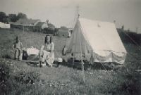
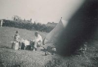
| I was in Worthing this past weekend to see friends who had recently moved there. Whilst there I attempted to locate a field where as a young boy of six I had camped with my mother and father in 1947. I have one photograph of family and tent. In 1951 we stopped at a guest house in Shoreham and revisited our camp site for which I have a further photograph on the reverse of which reads 'Our camp site at Wadmans or Wadhams Farm'. I
can recall:-
Best
regards, If anyone can shed any light on this, then please email memories@bn15.co.uk A Colin Godwin has replied: I think the village green that you referred to was Sompting Recreation Ground (also known as Sompting Rec). Down one side of the green was a row of farm cottages known as Orchard Cottages, they have been demolished long ago, and more modern houses were built in their place. I think they are called The Lawns, Loose Lane. At the far end of the cottages was Sompting Primary School, a part wood and flint building. (I was a pupil there back in 1956) and yes we used to dance round the Maypole on the village green. At the other end of the cottages in West Street was the Village Hall, which I think is still there. The campsite photo, does look like the field off
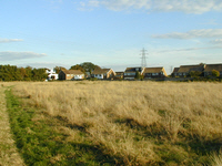
Dankton Lane, Sompting. If you look carefully in the centre of the
photo, you can see an electricity pylon. That is the pylon on the
village green, next to the public toilets. From Tim Clarke, Webmaster: I believe Colin Godwin is correct about the location of the campsite - it does indeed look like the field off Dankton Lane. I have taken the photograph below, which I think is roughly the same view today. The buildings have changes, but the pylons are a good clue, as is the tree line, which looks remarkably similar even after so many years.
Bill Sheridan has also commented, and has some memories of his own - Click here |